- 95Hachiro Lagoon Reclamation Embankment/Agricultural Water Intake Facility(A1)
- 96Hachiro Lagoon Reclamation Embankment/Agricultural Water Intake Facility(E2)
- 97Hachiro Lagoon Reclamation Embankment/Agricultural Water Intake Facility(D1)
- 98Chuo Main Drainage Canal/Nanbu Drain Pumping Station
- 99Ikkyu Main Drainage Canal/ Hokubu Drain Pumping Station
- 100Hamaguchi Drainage Pumping Station
-
title Hachiro Lagoon Reclamation Embankment/Agricultural Water Intake Facility(A1) one word explanation main facilities used to maintain Ogata-mura, reclaimed land keywords historydiscoverybeautiful confirm, register ー conservation laws and ordinances ー 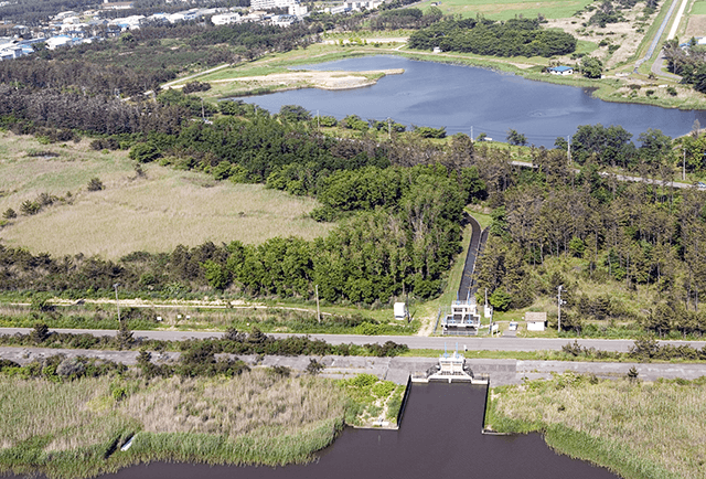
Born from the Hachiro Lagoon reclamation, the town of Ogata Village is surrounded by a 51.5km long embankment. Acting as the town’s lifeline, this bank took six years to build, beginning in 1958. The bank on the western canal was made using sand taken directly from the bottom of Hachiro Lagoon. The sand used for the embankment came entirely from Hachiro Lagoon, with some being transported from off the Futto coast in Oga and from the north and west parts of the lake. Over 25 million m3 of sand was used in building the embankment, enough to fill Tokyo Dome over 20 times. There are also 19 water intake facilities for use in agriculture, with nine on the western canal designed to use drains in the embankment. Because the canal is lower than the reclaimed land, the intake facility can draw water just by regulating the gate.
-
title Hachiro Lagoon Reclamation Embankment/Agricultural Water Intake Facility(E2) one word explanation main facilities used to maintain Ogata-mura, reclaimed land keywords historydiscoverybeautiful confirm, register ー conservation laws and ordinances ー 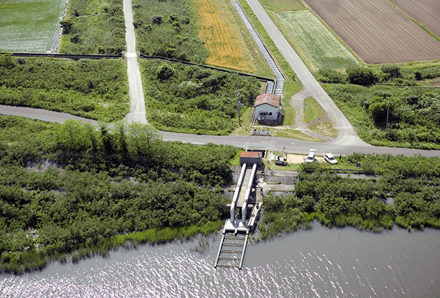
Born from the Hachiro Lagoon reclamation, Ogata Village is surrounded by a 51.5km long embankment. Acting as the town’s lifeline, this bank took six years to build, beginning in 1958. In areas where the lake bottom was weak, the embankment was created by digging 2m into the ground and replacing it with better quality sand, then piling more sand on top of it. For the sturdier sections of lake bottom, sand was poured directly on the lake bottom itself. The sand used for the embankment came entirely from Hachiro Lagoon. In addition, there are 19 water intake facilities for use in agriculture. Twelve of these, located on the Eastern Canal/Hachiro Lagoon Regulation Lake side, consist of steel pipes straddling the embankment in order to fortify it and draw water using siphons.
-
title Hachiro Lagoon Reclamation Embankment/Agricultural Water Intake Facility(D1) one word explanation main facilities used to maintain Ogata-mura, reclaimed land keywords historydiscoverybeautiful confirm, register ー conservation laws and ordinances ー 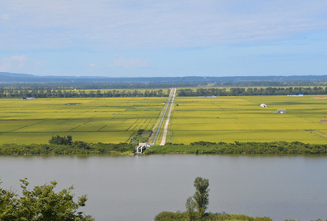
Born from the Hachiro Lagoon reclamation, Ogata Village is surrounded by a 51.5km long embankment. Acting as the town’s lifeline, this bank took six years to build, beginning in 1958. In areas where the lake bottom was weak, the embankment was created by digging 2m into the ground and replacing it with better quality sand, then piling more sand on top of it. For the sturdier sections of lake bottom, sand was poured directly on the lake bottom itself. The sand used for the embankment came entirely from Hachiro Lagoon. There are also 19 water intake facilities for use in agriculture. Twelve of these, located on the Eastern Canal/Hachiro Lagoon Regulation Lake side, consist of steel pipes straddling the embankment in order to fortify it and draw water using siphons.
-
title Chuo Main Drainage Canal/Nanbu Drain Pumping Station one word explanation the lifeline of Ogata-mura’s water circulation and water regulation keywords historydiscoverysearch confirm, register ー conservation laws and ordinances ー 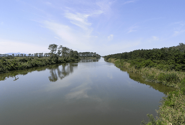
There are two main drainage canals. Stretching out 6.9km from east to west is the Ikkyu Main Drainage Canal, and bisecting it orthogonally is the 15.7km Chuo Main Drainage Canal. The total length of the branch canals and smaller drainage pipes is 620.7km. The Chuo Main Drainage Canal is also used for rowing and boat races. There are three drainage pumping stations, Nanbu, Hokubu, and Hamaguchi, which work together to regulate the water levels in the regulation lake and drains.
-
title Ikkyu Main Drainage Canal/ Hokubu Drain Pumping Station one word explanation the lifeline of Ogata-mura’s water circulation and water regulation keywords historydiscoverysearch confirm, register ー conservation laws and ordinances ー 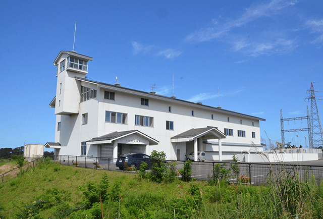
There are two main drainage canals. Stretching out 6.9km from east to west is the Ikkyu Main Drainage Canal, and bisecting it orthogonally is the 15.7km Chuo Main Drainage Canal. The total length of the branch canals and smaller drainage pipes is 620.7km. The Chuo Main Drainage Canal is also used for rowing and boat races. There are three drainage pumping stations, Nanbu, Hokubu, and Hamaguchi, which work together to regulate the water levels in the regulation lake and drains.
-
title Hamaguchi Drainage Pumping Station one word explanation the lifeline of Ogata-mura’s water circulation and water regulation keywords historydiscoverysearch confirm, register ー conservation laws and ordinances ー 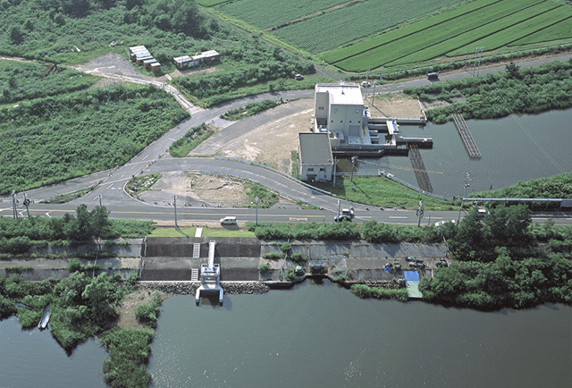
There are two main drainage canals. Stretching out 6.9km from east to west is the Ikkyu Main Drainage Canal, and bisecting it orthogonally is the 15.7km Chuo Main Drainage Canal. The total length of the branch canals and smaller drainage pipes is 620.7km. The Chuo Main Drainage Canal is also used for rowing and boat races. There are three drainage pumping stations, Nanbu, Hokubu, and Hamaguchi, which work together to regulate the water levels in the regulation lake and drains.