-
title Hachiro Lagoon Reclaimed Land Canola Flower Field one word explanation flower garden that appeared on the reclaimed land of Hachirogata keywords naturehealingbeautiful confirm, register ー conservation laws and ordinances ー 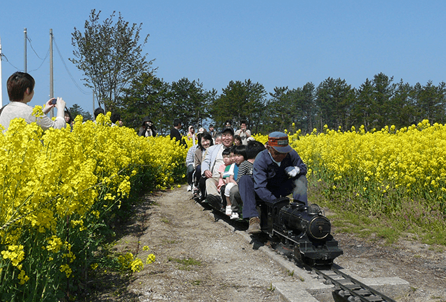
Cultivation of canola flowers in Ogata Village began in 1991. It began with an idea to plant canola flowers as a scenic crop, and cultivation was undertaken by the Ogatamura Koushinkai, a senior citizens organization involved in townscape planning, volunteerism, and social gatherings. After some trial and error, by 1994, flowers bloomed in the field in front of Hotel Sun Rural Ogata and along the roadsides throughout the town, and the first “Canola Flower Festival” was held. Later, in 1997, tracks were laid in the field for a mini steam locomotive train. The “Cherry Blossom and Canola Flower Festival” is held every year during Golden Week, drawing large crowds. Because the canola flower does not grow well with repeated cultivation, the Ogatamura Koushinkai has been researching ways of continuing to grow these beautiful flowers in the same field on a yearly basis.
-
title View from the Hotel Sun Rural Ogata one word explanation Hachirogata was possible because Oga Island existed / Come take a look around the relcaimed land of Hachirogata keywords geologynaturebeautiful confirm, register ー conservation laws and ordinances ー 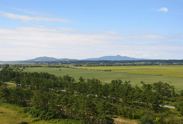
Surrounded by the countryside of Ogata Village’s reclaimed land, the Hotel Sun Rural Ogata prides itself on the local seafood and vegetables used in its cuisine. From the guest rooms and the Ogata Moor Hot Spring on the 8th floor, you can see Mt. Chokai and the Shirakami Mountains in the distance, as well as enjoy the view of Ogatamura’s reclaimed land and the Oga Peninsula.
Address: 1-3 Aza-Kita, Ogatamura, Minamiakitagun -
title Ogata Moor Onsen (Hot Spring) one word explanation a hot spring originating from the stratum of 5 million years ago keywords healingfoodgeology confirm, register ー conservation laws and ordinances ー 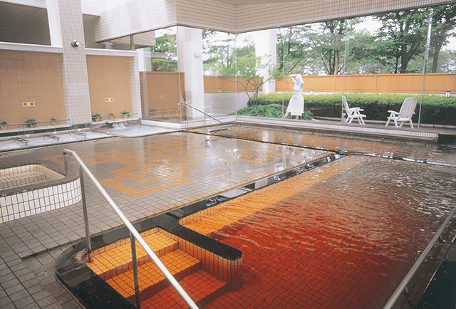
The word “moor” is German for humus. Unlike volcanic hot springs, the Ogata Moor Hot Spring is a yellowish brown and has 6mg of humus per liter of water, making it a rarity among Japanese hot springs. The spring has two sources, located about 1.5km to the southwest, with water drawn from a depth of about 900m. Ogata Village was born from the land reclamation of Hachiro Lagoon, but in ancient times the entire Hachiro Lagoon area was deep under the sea. Layers of sediment on the ocean floor formed the foundation of Ogata Village’s land. The hot spring comes from a sand layer within a 4-5 million year old mudstone stratum (Tentokuji Formation). It is said that the hot spring was formed by water and humus being heated deep underground in this sand layer.
Address: 1-3 Aza-Kita, Ogatamura, Minamiakitagun -
title Ogata Steppe Wildlife Sanctuary/Ogata Steppe Bird-Watching Facility one word explanation The reclaimed land of Hachirogata is a paradise for wild birds that have emerged keywords natureexperiencediscovery confirm, register ー conservation laws and ordinances Protection and Control of Wild Birds and Mammals and Hunting Management Law 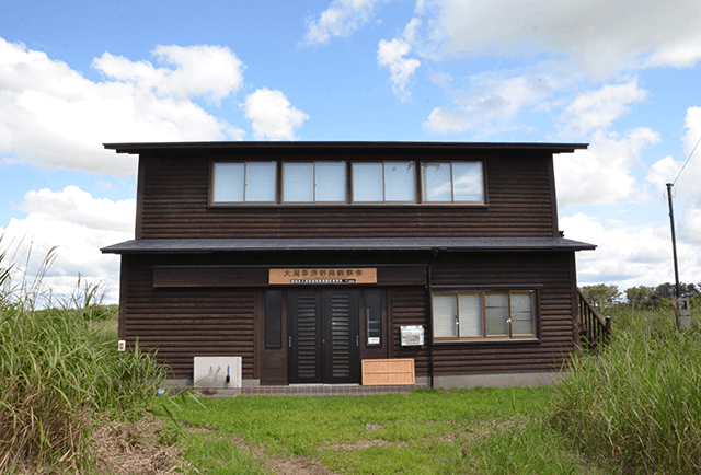
After the near-mythical Japanese swamp warbler was confirmed to be breeding in Akita Prefecture in 1973, the Ogata Steppe Wildlife Sanctuary was founded in 1977. Renamed the Ogata Steppe Bird-Watching Facility to coincide with Ogatamura’s 50th anniversary in 2014, the meadows are now the breeding grounds for such rarities as the Japanese swamp warbler and Japanese reed bunting, and the waterside is used as a stop over by wild ducks on their migration. Around 80 different types of birds can be observed at various times throughout the year.
Address : 5-4 Aza-Nishi, Ogamura, Minamiakitagun -
title Intersection Point of Longitude and Latitude one word explanation crossroad of the Earth that appeared on the ground surface keywords historydiscoverybeautiful confirm, register ー conservation laws and ordinances ー 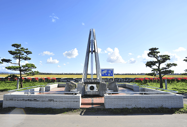
The lines of 140°east latitude and 40°north longitude pass almost right through the center of Ogata Village. As this is the only place on Japanese soil where lines of even 10 degree intervals cross, there is a monument where the two lines meet. This used to be the bottom of Hachiro Lagoon. When Hachiro Lagoon was drained during the land reclamation that began in 1957, a new land was born from the bottom of the lake, and with it, the first “Earth’s Crossroads”, where the intersection of even 10 degree lines was revealed on Japanese soil.
Note: The Tokyo Datum, used from the Meiji Era (1868-1912) until April 1st, 2002, was a coordinate system that set latitude and longitude based on the old National Observatory in Tokyo. In the days of GPS, the coordinates are set by the World Geodetic System, which places the intersection of 140°east latitude and 40°north longitude 430m southeast of the monument. -
title Cherry Trees and Canola Flower Road one word explanation vivid contrast of pink and yellow keywords historybeautifulhealing confirm, register 100 aromatic landscapes conservation laws and ordinances ー 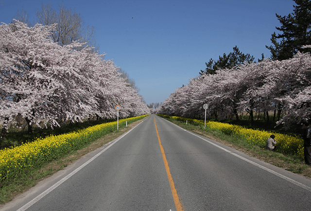
The cherry trees were planted along about 11km of Prefectural Highway 298 to celebrate Ogata Village’s 20th anniversary over three years, starting in 1984. There are 3,000 trees in total from three different varieties: the Yoshino cherry, the Yaezakura cherry, and the North Japanese hill cherry. In 2014, to celebrate the town’s 50th anniversary, an additional 1,000 Yoshino cherry trees were planted. Many of the townspeople helped in planting these trees. At the base of the trees are canola flowers, planted by the Ogatamura Koushinkai, a senior citizens organization involved in townscape planning, volunteerism, and social gatherings. Most years, both the cherry trees and the canola flowers bloom around Golden Week in late April/early May, allowing you to enjoy the brilliant contrast of pink and yellow.
nature of Ogata-mura
Home >
What is the Oga Peninsula - Ogata Geopark? >
Geosites and spots >
Ogata area >
nature of Ogata-mura