-
title Craters one word explanation Mt. Kanpuzan was a volcano keywords geologynatureculture confirm, register Oga Quasi-National Park conservation laws and ordinances Natural Parks Act 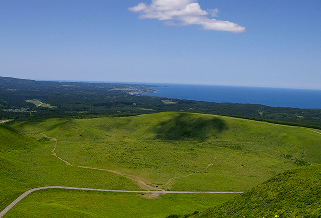
Mt. Kanpuzan is a 355m tall volcano. From the beginning of its volcanic activity more than 30,000 years ago, its size has increased through the buildup of andesite lava, giving it the shape we see today. There are presently three craters that can be observed, Crater 1, Crater 2, and the Tsumakoi Pass Crater, as well as the traces of lava at Itaba no Dai Caldera. Mt.Kanpuzan is formed primarily of andesite, covered by a layer of top soil and vegetation. Also called “Oga Rocks”, this stone is widely used for things such as dikes, garden stones, gravestones, and more, and is an inextricable part of our life.
-
title Itaba no Dai Caldera one word explanation minature garden of the volcano keywords geologybeautifuldiscovery confirm, register Oga Quasi-National Park conservation laws and ordinances Natural Parks Act 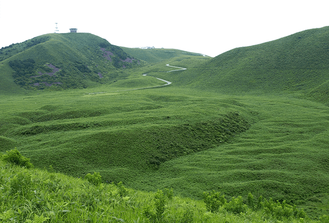
Distinguished from the surrounding area by its flatter land, Itaba no Dai Caldera contains waves and embankments called “lava waves” and “lava levees” that were formed by lava flowing out of Tsumakoi Pass Crater. Although neither seem particularly large, the lava waves reach about 2m and the lava levees about 5m. This area is the ideal spot to view the volcano as a whole. In addition, you can see many flowers, including erigeron thunbergii in spring, lilium auratum in summer, and swertia japonica in autumn.
-
title Rotating Observatory one word explanation Observatory overlooking Oga Peninsula and Ogata keywords naturefoodbeautiful confirm, register Oga Quasi-National Park conservation laws and ordinances Natural Parks Act 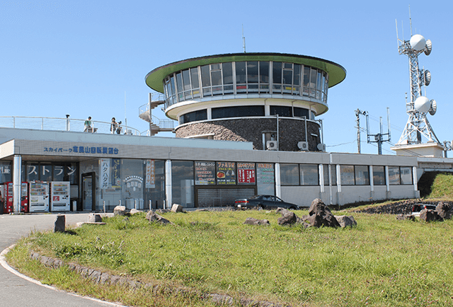
Opened in Showa 1964, this rotating observatory was subsequently remodeled in 1988. A single rotation takes 13 minutes, during which time you can enjoy a 360°panoramic view without ever leaving your seat. From the observatory, you can see Ogata Village, Japan’s largest manmade landmass, which was created by reclaiming land (draining the water) from Hachirogata Lagoon, formerly one of the largest lakes in Japan and second only to Lake Biwa. The reclamation began in 1957 and was completed in 1977.
-
title Mt. Himegatake one word explanation The legendary mountain crossed by a large serpent keywords geologylegendbeautiful confirm, register Oga Quasi-National Park conservation laws and ordinances Natural Parks Act 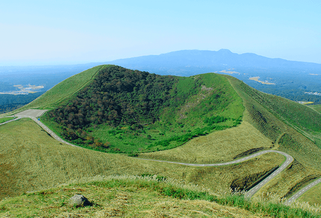
On the near side of one of Mt.Kanpuzan’s two peaks, at a height of 337m, is a second crater called Kotama no Ike Pond. There is a myth about a giant serpent associated with this crater. Long ago, the crater was filled with water and a girl named Otama threw herself into it rather than be forced into an unwanted marriage, giving it the name Tama no Ike (Tama’s Pond, later Kotama no Ike, or Old Tama’s Pond). Otama transformed into a giant serpent, but the lake eventually dried up and she moved to the present-day Tama no Ike (Shintama no Ike, or New Tama’s Pond). It is said she left a ridge of mountains in her wake, which is now called Jakoshi Nagane (Long Root of the Serpent’s Passing).
-
title Oni no Kakurezato (Hidden Ogre Village) Rocks one word explanation Made by ogres? Traces of the volcano keywords geologylegendhistory confirm, register Oga Quasi-National Park, One hundred strange sotones from Japan conservation laws and ordinances Natural Parks Act 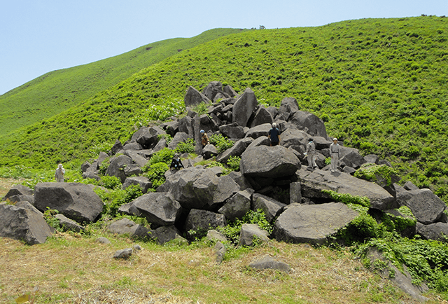
Known for the Oga no Namahage ogres, Oga Peninsula has many place names related to ogres. Oni no Kakurezato (Hidden Ogre Village)Rocks is a pyramid-shaped formation of large rocks, which gained its name from the myth that ogres secretly lived in a rocky mountain they made by piling stones on top of each other. In reality, it is thought to have been created through volcanic activity in which viscous lava was pushed up from underground, forming pillars, which then crumbled.
-
title Earthquake Memorial one word explanation pray for the earthquake victims commemorative memorial keywords historydisaster preventionexperience confirm, register Oga Quasi-National Park conservation laws and ordinances Natural Parks Act 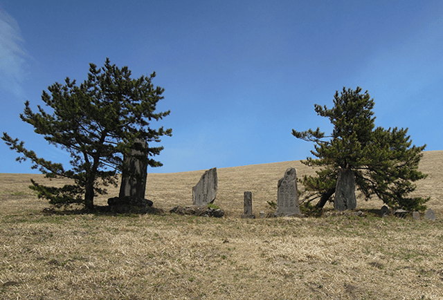
There are five memorial stones in total, including those in remembrance of the earthquakes that have struck Oga Peninsula, in commemoration of the post-earthquake reconstruction, and in remembrance of those who died during famine. The oldest memorial was built in remembrance for the earthquake of 1810. Masumi Sugae, who was living in Oga at the time, wrote in “Oga no Samukaze” of his experience of the earthquake, saying, “The destruction was so widespread that hardly a building remains in any village.” Then in the earthquake of 1939, 28 lives were lost and 1,663 buildings damaged. These memorials are a message to the future, which speak to us of disaster that will not be forgotten.
-
title Takinogashira Spring one word explanation the gift of Mt. Kanpuzan, delicious water keywords naturehistoryhealing confirm, register Oga Quasi-National Park conservation laws and ordinances Natural Parks Act 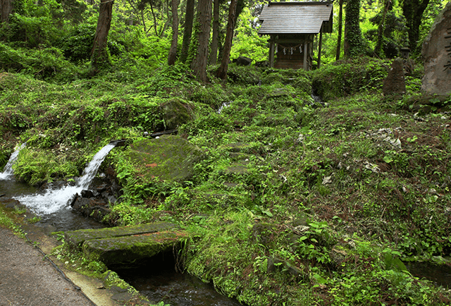
With an enormous output of about 25,000㎥ a day (2013 data), this spring makes up 70% of Oga Peninsula’s famous water from the base of Mt.Kanpuzan. Snow melt and rain soak into the base of Mt. Kanpuzan, becoming purified and infused with minerals while flowing through inside of the volcano. It is thought to take about 20 years for this natural filtration process to occur before the water gushes forth into the open. Used for both agriculture and drinking water throughout Oga Peninsula, this spring is truly a blessing of the volcano. The 38-hole cylindrical water diversion used to distribute water evenly is also an impressive sight.
Mt. Kanpuzan
Home >
What is the Oga Peninsula - Ogata Geopark? >
Geosites and spots >
central area >
Mt. Kanpuzan